Conference Travel
Coming By CarHere are our driving instructions, famous since 1993. They are divided into segments, depending on which direction you will be coming from. At one point ("Final Approach"), all directions converge. But first:
Before Setting Out
Except for dinners, all Conference events will be under the same roof, at the UMass Campus Center. But for those occasions, your personal preparation should include a rain hat or waterproof scarf, light raincoat, penlight in pocket or purse, perhaps a folding umbrella). For your car, note additionally the following:
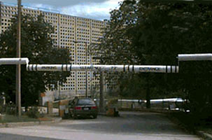
(1) Clearance at the Campus Center Parking Garage is limited to 7' 2." A boom just before the entrance will tell you if you are in compliance, but it is then too late to change cars. (2) Be sure wipers are in working order; all-weather ones are recommended. Rain can be heavy. (3) Be sure your radiator and coolant are in good condition; delays can sometimes occur if you arrive or depart at peak time. (4) Be sure your license, registration, and insurance papers are handy. This is a rude driving area, and scrapes are common. Plan to drive circumspectly. (5) Print out and bring with you these instructions, including the simple Campus Map. (6) Speed limits on campus are 30 mph, and caution is advised. Crosswalks are not well marked, pedestrians can be arrogant or thoughtless, and fatalities have occurred. Don't be involved in the next one. (7) Be advised that since summer 2013 the UMass/Amherst campus is a completely non-smoking area.
For those using GPS, the Campus Center Hotel is at 1 Campus Center Way, Amherst MA 01002. This will however probably take you to the front entrance, not the garage entrance (shown above). For those using taxi, the Campus Center Way address is correct: it will deliver you to the hotel lobby. If you are using the Valley Transporter shuttle for your return trip, it will stop at at this entrance, outside the lobby.
It is common in Massachusetts to mark the side streets with signs, but not the major street on which you happen to be traveling. This can make for confusion. It is also common for signs indicating the side turns to be fully visible only after you have successfully made your turn. On campus, street signs are not in standard green but in official University maroon, not the most visible color at night. They are also undersized. Don't expect to find your way to your destination by ignoring our seemingly overdetailed instructions and navigating by local signage. Print out the instructions and bring them with you. Laugh all you want, but print them out. All right?
Direction of Approach
Click below to skip to the relevant part of this page:
This is the route of choice for those coming from Worcester or other centrally located places. Take it slow. Route 9 is an upgraded goat track that winds between various picturesque small towns, and divides in unmarked ways as it does do. Be especially alert in the vicinity of Brookfield, and when in doubt, always take the left fork. From Brookfield on, your chief vexation will be getting stuck behind a slow-moving car which due to the nature of the road you cannot safely pass. Be normally watchful for local traffic and local pedestrians. Don't ride your brakes down the long descent into the Connecticut Valley from Brookfield to Ware. Use a low gear. In Ware, be alert to stay in the correct (through) lane, which unfortunately changes periodically. Once out of Ware, the worst is over.
As you approach Amherst, and begin the slow rise to Amherst Center, be also watchful for Amherst College students. The campus lines both sides of Route 9 in this vicinity, and jaywalking is a way of life. The light at the top of this rise is the intersection with Route 116, which enters from the left (south), makes a left turn, and will join you for the next few blocks. As you wait for that light, the Amherst town common is on your right. Continue straight through the light and follow Route 9 as it bears slightly left and down a slow hill. At the bottom of that hill, Route 9 continues straight ahead through a strip shopping center. Follow it, but be in the right lane. At the third light, you will see signs for Route 116 and UMass. Take the turnoff just before the light onto Route 116 North. At this point we join the traffic reaching Route 116 from the other direction.
From the East via the Mass Turnpike
The drive from Boston is about two hours at legal speeds for inexperienced drivers. Some Worcester visitors will also prefer to avoid Route 9 and instead go west on the Turnpike, which is longer but also faster. The exit both of you want is Exit 4 (West Springfield). It comes up rather quickly after you cross the Connecticut River Bridge, so get into the right-hand lane as soon as you pass Exit 5 (Holyoke). For further instructions, see the next section.
From the West via the Mass Turnpike
Your exit is also Exit 4 (West Springfield); don't be tempted by Exit 3. As you come off the exit ramp going toward the toll booths, you will merge with drivers coming from the east. Both of you will want to be in a leftish tollbooth lane. You are in good shape; they must cautiously work to the left. At the tollbooth, you may find that you are waved through after presenting your ticket, since travel is free on the western end of the Turnpike. Immediately past the tollbooths, take the option on the left, labeled I-91 / Holyoke. The uphill roadway bends left, then sharply right. Just before the crest of the hill, exit right for I-91 North. You will now join traffic which is heading up I-91 from the south. Continue reading the next section for those instructions.
Hello, New York and New Haven people, as you cross the Massachusetts line from the south. Now slow down. This section of I-91 is heavily patrolled, and state police speed traps abound in the picturesque hills ahead. Speed limits are lower (55, in spots even 50), and lanes are fewer, where I-91 goes through Springfield. Posted speed otherwise is 65. The typical actual speed is nearer 75, but that precedent won't help you in any roadside conversations with the state police in their sometimes unmarked cars.
Under normal conditions, it is about an hour from the Mass Pike intersection to your destination.
Those merging into I-91 just north of the Mass Pike crossing will need to get into at least the center lane, since the right lane will end in a short time. You also want to get clear of mall on and off traffic in this immediate vicinity. Be careful changing lanes, but manage somehow. Once the road becomes two-lane, we recommend the right lane, where you can more comfortably follow the speed limit.
And why? Because this is a state police income area. Speed traps are especially thick between Exits 17 (Easthampton) and 18 (Northampton). Your exit to pick up Route 9 for Hadley and Amherst is Exit 19 (Amherst / Route 9). Traffic may be congested at the point where the exit ramp joins Route 9; be patient. Get in the right turn lane. As you wait to join Route 9, set your trip odometer to zero. We are going to talk you in on instruments, and the odometer is the instrument.
After making that right turn, you will be crossing the Coolidge Bridge, heading toward Amherst. You are probably in the right lane. Beware that the two bridge lanes merge to one just past the bridge. Watch out for stopped cars trying to turn left (into a side road) against oncoming traffic just at the point of merger.
Landmarks. Moving eastward along Route 9 (locally called Russell Street), there is a light at mile 1.0 (the intersection with Route 47). At 1.8 miles there is another light, near the Hadley town hall and (very often) a parked police cruiser. This is a school crossing and needs your attention, in and out of school season. At 4.0 miles is a traffic light at the entrance to the Mountain Farms Mall (anchored on a WalMart). Immediately following, at 4.1 miles, is another light at Maple Street. Avoid the right turnoff and left turn lanes, and keep going straight. Just past the light, there is another mall on your right (the store nearest to Route 9 is Trader Joe's). Once past Maple Street, work into the left lane, and as the next light approaches, get into the left turn lane for Route 116 North and UMass. (The local Staples store will be visible to the right). That lane will appear at about 4.7 miles. Make your left turn onto 116 as soon as you get the green arrow.
We now join our friends coming from the east via Route 9. Beware of merging traffic on the right (it may be them). Obviously, the odometer settings given here do not apply to them, but they may convert by subtracting 4.8 from the readings given here.
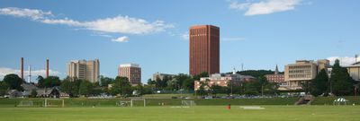
As you (both) go north along Route 116, the UMass campus skyline, including high-rise dorms as well as the landmark Library Tower, should become visible on your right. If you happen to get here at sunset, the sunset will be spectacularly visible at your left. Pay no attention to it. Concentrate on the UMass exit ramp at mile 6.0. At the end of that ramp, bear right (toward campus), after yielding to any traffic in the road ahead of you.
You are now going east on the campus road called Massachusetts Avenue, and our friends arriving from the north are on that same road, also going east. You may now skip to Final Approach, which resumes guiding you after we have first given our northern friends their instructions.
Get off at Exit 25 (Deerfield). Turn right at the end of the ramp and follow the road to the light at the intersection with Routes 5/10 South. Turn right, go 1 mile, and then turn left at the light onto Route 116 South, to Sunderland. If you are running low on fuel, there is a Mobil station on your right just at the turn. Once over the scenic bridge into Sunderland, you will pass another Mobil station just before the Route 47 light (about two miles along), a Sunoco station just past that light on your left, and a Citgo one about three miles further on, also on your left, just before the Amherst town line sign.
Just past that is a light at the intersection with Route 63. Continue on straight. The road will presently divide, and the UMass exit lane comes very soon after that divide. Take it, turn left at the top of the exit ramp onto the campus road called Massachusetts Avenue. You will recross Route 116 on the overpass. The skyline of the UMass campus is directly in front of you. Give it a glance, but otherwise concentrate on traffic.
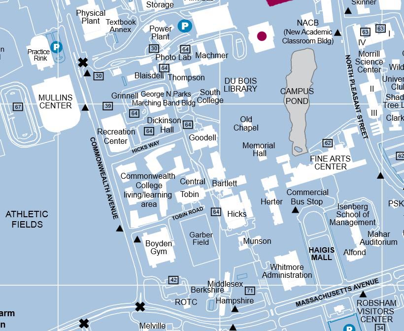
All car travel variants are now going east on Massachusetts Avenue, just past the Route 116 turnoff. The view ahead of you (if you arrive by day) is roughly the above. Those arriving from the south via I-91 and the Coolidge Bridge option are at mile 8.2. Here is a map of the area, to orient you for the following instructions.
Just ahead is a blinker light. Go through it with caution, and get in the lane for a left turn at the next traffic light, which marks Commonwealth Avenue. As you wait at the light, the huge and costly Mullins Center stadium with its hideous green roof and its adjoining green playing fields is to your left. Keep the Mullins in mind as a landmark. Be very alert for pedestrian traffic, both in and out of the crosswalks. If anything, stay under the campus speed limit of 30. If there is an event at the Mullins, or if you hit the rush hour, there may be campus police in orange slickers directing traffic. Give priority to their suggestions.
As you proceed on Commonwealth Avenue, past the new Commonwealth College buildings on your right, the Mullins Center will loom up on your left. Your right turn to the Campus Center Garage is at the light just opposite the Mullins Center (there is an X on the above map). It leads to a winding uphill road which ends at the Garage. Do not look for the Power Plant, which is no longer there. Just follow the road. The Parking Garage is marked P on the above map.
The Garage entrance is not where it looks like it should be, but down a short ramp to your right, under the 7' 2" clearance boom pictured at the top of this page. Stop at one of the entrance lanes. You must push the button on the ticket machine before it will print you a ticket. Take the ticket and go through the gate (which will raise for you). Enter the building cautiously, and turn on your lights as you do so. If there has been rain, traction on the garage concrete will be poor. Observe the 5 mph limit.
You are now on Garage Level 3. If you were attending a regular campus event, you would try to park there, since it is more or less level with the surrounding ground. Instead, you are heading for the Hotel, and want to park on Level 2. Go straight, turn right at the corner of the building, go past the up-ramp (on your right), turn right again at the next corner and also at the one after that. You will now have a down-ramp on your right. Take it (slowly) down to Level 2, actually the lowest level of the garage as presently implemented. At the bottom of the down-ramp you will see ahead of you (and slightly to your right) the CONCOURSE ENTRANCE sign indicating the tunnel to the Campus Center proper. Park as near to that door as is legal (the best spaces are handicapped ones, which most of you cannot use). Turn off your headlights. Gather your luggage, lock your car, and go to the Concourse sign. If you arrive after 2 AM, instructions there will direct you to the front entrance of the Center, which is always open. Otherwise, go through the tunnel. Follow it into the building, dogleg left (the Campus Store entrance will be in front of you halfway through the dogleg) and head for the elevators, which will be on your right. Take the elevator to Level 3, and check in at the Reception desk.
Basic instructions are to reverse the above procedures. On exiting the Parking Garage for the last time, surrender your parking pass.
One special caution: If you are going south on I-91, waiting for the Mass Turnpike turnoff, you should find no trouble locating that exit, which after an initial bend will take you down a long straight descent. But remain alert to make a right turn near the bottom of that descent, to get to the actual tollbooths; otherwise the ramp will take you all the way to Route 5. Don't let up at the last minute, or the Massachusetts highway engineers will get you after all.
Thanks for your patience with the hazards of travel, and with these instructions. We now rejoin the main Travel Advice page at the point where we left it.
14 Sept 2005 / Contact The Project / Exit to Conferences Page