|
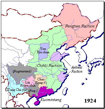
| China Map 2: Modern Warlord Domains | |
|
| China Map 2: Modern
Warlord Domains
Allowance must be made for the fact that the pre-Imperial multi-state system did not reach beyond the Yangdz River or north into modern Manchuria, so that the southern portion of this map is by definition irrelevant: outside the zone of valid comparison. Outside that, what we chiefly see is the breakaway nature of the most recently acquired territories in the south and southwest. Within it, the "Yen Syi-shan" [my spelling] area corresponds to the northern state of Jau, and the northernmost of the two purple areas of the "Anhwei Faction" corresponds to the eastern states of Chi and Lu. "Jau Hvng-ti" seems to have occupied the upper Yangdz River territory of Chu, but nothing else is left, on this map at least, of this once mighty entity.
All lectures and abstracts posted on this site are Copyright © by their authors. 19 Apr 2002 / Contact The Project / Conferences Page |